

CFVR1604 - Active Pressure acting on 3D Beams
Active Pressure of a terrain acting on a 3D Beams structure.
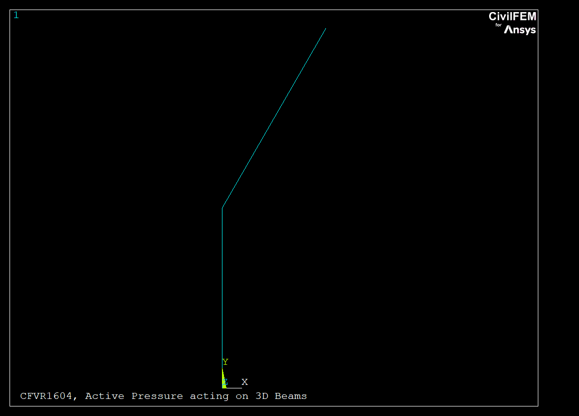
A terrain surrounds a structure made up of 3D beam elements. The purpose of this example is to apply the equivalent loads of the terrain on the structural model.
The structure is a half frame with inclined walls as shown in the figure, with a total height
The terrain is defined by a single soil material with the following parameters:
- Friction angle between the ground and wall: 15º
- Slope angle of the ground: 10º
- Uniform surface load on the ground per unit of slope length: 0.1 Tn/m2
- Ground level: 5.0 m measured from the bottom of the structure
- Water table level: 3.0 m measured from the bottom of the structure
- Porosity: 0.3
- Dry specific weight 2.0 Tn/m3
- Internal friction angle: 30º
Element types used in the model: BEAM4 Needed CivilFEM Modules: |
|
| Model Statistics | |
| Number of elements | 2 |
| Number of nodes | 3 |
| Number of civil materials | 2 |
| Number of cross sections | 1 |
| Number of shell vertices | 0 |
Log file: CFVR1604.DAT
! DESCRUPTION: of 2.0 m. FINISH ~CFCLEAR,,1 NomFile='CFVR1604' /TITLE, %NomFile%, Active Pressure acting on 3D Beams ~CFACTIV,GETC,Y ! Geotechnical module activation ! --------------------------------------------------------------------------------- ! Model definition ! --------------------------------------------------------------------------------- ! Civil Setup ~UNITS,,LENG,M ~UNITS,,TIME,S ~UNITS,,FORC,MP /PREP7 ! Preprocessor ET,1,Beam4 ~CFMP,2,LIB,CONCRETE,EC2,C25/30 ~CSECDMS,1,REC,2,1,1 ~BMSHPRO,1,BEAM,1,1,,,3,1,0 N,1,0,0 N,2,0,1 N,3,0.5774,2 E,1,2 E,2,3 EPLOT /IMAGE, SAVE, %NomFile%,BMP DELTA= 15 ! Friction angle between the ground and wall, in degrees BETA= 10 ! Slope angle of the ground, in degrees Q= 0.1 ! Uniform surface load on the ground per unit of slope length EAKCN= 0 ! Reference number of the coordinate system in which the ground is defined EAH= 5.0 ! Ground level next to the wall WKEY= 1 ! Code identifying the influence of the water WH= 3.0 ! Water Table ~CFMP,1,LIB,SOIL,,SW ~CFMP,1,SOIL ,N ,,0.3 ~CFMP,1,SOIL ,GAMD ,,2.0 ~CFMP,1,SOIL ,PHIMCEFF,,30 ~TERDEF,1,NEW,2,EAKCN,Y,EAH,BETA, Q, WKEY, WH, Terrain 1 ~TERDEF,1,LAYER,1,1,1.0,0,CLMB,DELTA ~TERDEF,1,LAYER,2,1,2.0,0,CLMB,DELTA ~ETHSFE,2,ACT,1,1.0,1.0 ! Active Pressure ! --------------------------------------------------------------------------------- ! DATA CHECK ! --------------------------------------------------------------------------------- ! Data comparison number NComp = 4 NComp_ch = 0 ! Marix dim. *DIM,LABEL,CHAR,Ncomp,1 *DIM,LABEL_CH,CHAR,Ncomp_ch,1 *DIM,VALUE,,Ncomp,3 *DIM,VALUE_CH,CHAR,Ncomp_ch,3 *DIM,TOLER,,Ncomp,2 ! Labels ! --------------------------------------------------------------------------------- LABEL(1) ='Pn1' LABEL(2) ='Pt1' LABEL(3) ='Pn2' LABEL(4) ='Pt2' ! Correct Values VALUE( 1,1)= 5.653 VALUE( 2,1)= -0.711 VALUE( 3,1)= 6.107 VALUE( 4,1)= -1.100 ! Obtained values *GET,VALUE(1,2),ELEM,1,PRES,2 *GET,VALUE(2,2),ELEM,1,PRES,3 *GET,VALUE(3,2),ELEM,2,PRES,2 *GET,VALUE(4,2),ELEM,2,PRES,3 ! Warning and error tolerances *DO,I,1,NComp TOLER(I, 1)= 1E-2 $ TOLER(I, 2)= 1E-2 *ENDDO ! --------------------------------------------------------------------------------- ! Results Comparison ! --------------------------------------------------------------------------------- COMPARA.MAC |
Results
| Label | Target | CivilFEM | Ratio | Tolerance |
| Pn1 | 5.653 | 5.6517 | 1.000 | 0.01 |
| Pt1 | -0.711 | -0.71053 | 1.001 | 0.01 |
| Pn2 | 6.107 | 6.1114 | 0.999 | 0.01 |
| Pt2 | -1.1 | -1.1016 | 0.999 | 0.01 |
Contains proprietary and confidential information of Ingeciber, S.A.