

CFVR3303 - Retaining Wall 2D Geometry checking
Retaining wall depth + anchorages length checking
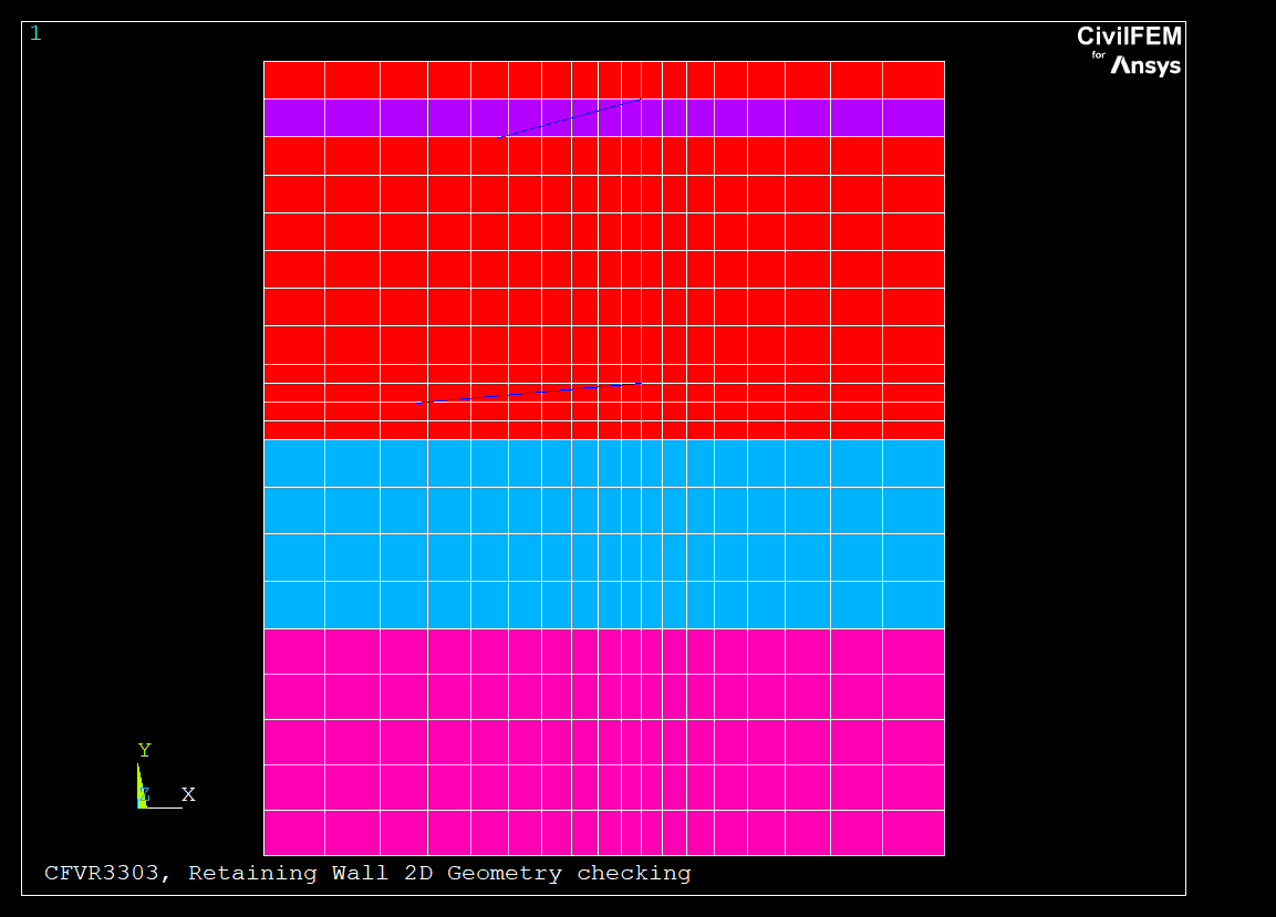
This example test the geometry of the model generated with the Retaining Wall tool in Geotechnial Module, comparing the size of the model with the variables introduced.
The example loads the test model which creates the following structural materials:
- C40/50 concrete for the wall.
- S400 steel for the reinforcement and anchorages.
- Fe 430 steel for the anchorages shapes.
- Layer 1: Sand Well Graded. 2 m thickness.
- Layer 2: Gravel Well Graded. 8 m thickness.
- Layer 3: Diorite. 5 m thickness.
- Layer 4: Sand. 6 m thickness.
The construction process is defined as follows:
- Step 1: Terrain is excavated to level 1000m.
- Step 2: Terrain is excavated to level 999m.
- Step 3: Terrain is excavated to level 998m. An anchorage is placed at level 998,5m.
- Step 4: Terrain is excavated to level 997m.
- Step 5: Terrain is excavated to level 996m.
- Step 6: Terrain is excavated to level 995m.
- Step 7: Terrain is excavated to level 994m.
- Step 8: Terrain is excavated to level 993m.
- Step 9: Terrain is excavated to level 992m.
- Step 10: Terrain is excavated to level 991m. An anchorage is placed at level 991,5m.
- Step 11: Terrain is excavated to level 990m.
Element types used in the model: PLANE182, BEAM3, LINK8, TARGE169, CONTA171 Needed CivilFEM Modules: |
|
| Model Statistics | |
| Number of elements | 391 |
| Number of nodes | 442 |
| Number of civil materials | 12 |
| Number of cross sections | 2 |
| Number of shell vertices | 0 |
Log file: CFVR3303.DAT
FINISH ~CFCLEAR,,1 ~CFACTIV,GETC,Y NomFile='CFVR3303' /TITLE, %NomFile%, Retaining Wall 2D Geometry checking !------------------------------------------------------------------------ ! Initial data !------------------------------------------------------------------------ /PREP7 ~RTNWGUI,Test2D !------------------------------------------------------------------------ ! DATA CHECK !------------------------------------------------------------------------ ! Data comparison number Ncomp = 3 Ncomp_ch = 0 ! Matrix dim. *DIM,LABEL,CHAR,Ncomp,1 *DIM,LABEL_CH,CHAR,Ncomp_ch,1 *DIM,VALUE,,Ncomp,3 *DIM,VALUE_CH,CHAR,Ncomp_ch,3 *DIM,TOLER,,Ncomp,2 ! Labels !------------------------------------------------------------------------ LABEL(1,1) = 'ANCH' LABEL(2,1) = 'DEPTH' LABEL(3,1) = 'STRET' ! Obtained values !------------------------------------------------------------------------ ESEL,S,TYPE,,3 *GET,NESEL3,ELEM,,COUNT IE = 0 mlengthAnchorage = 0 *DO,I,1,NESEL3 IE = ELNEXT(IE) IE1 = NELEM(IE,1) IE2 = NELEM(IE,2) mlengthAnchorage = DISTND(IE1,IE2) + mlengthAnchorage *ENDDO ESEL,S,TYPE,,2 *GET,NESEL2,ELEM,,COUNT IE = 0 mretainingWallDepth = 0 *DO,I,1,NESEL2 IE = ELNEXT(IE) IE1 = NELEM(IE,1) IE2 = NELEM(IE,2) mretainingWallDepth = DISTND(IE1,IE2) + mretainingWallDepth *ENDDO ALLSEL *GET,maxX,NODE,0,MXLOC,X *GET,minX,NODE,0,MNLOC,X mstretch = maxX - minX /IMAGE,SAVE,%NomFIle%,BMP VALUE(1,2) = mlengthAnchorage VALUE(2,2) = mretainingWallDepth VALUE(3,2) = mstretch ! Correct values !------------------------------------------------------------------------ VALUE(1,1)=10 !Length of the anchorage VALUE(2,1)=9.5 !Depth of the terrain VALUE(3,1)=18 !Stretch length ! Warning and error tolerances TOLER( 1, 1)= 1E-2 $ TOLER( 1, 2)= 1E-2 TOLER( 2, 1)= 1E-2 $ TOLER( 2, 2)= 1E-2 TOLER( 3, 1)= 1E-2 $ TOLER( 3, 2)= 1E-2 !------------------------------------------------------------------------ ! Results comparison !------------------------------------------------------------------------ COMPARA.MAC |
Results
| Label | Target | CivilFEM | Ratio | Tolerance |
| ANCH | 10 | 10 | 1.000 | 0.01 |
| DEPTH | 9.5 | 9.5 | 1.000 | 0.01 |
| STRET | 18 | 18 | 1.000 | 0.01 |
Contains proprietary and confidential information of Ingeciber, S.A.